Pacific Leaders settle areas of National Maritime jurisdiction
Thursday, 30 August 2012 14:17
administrator

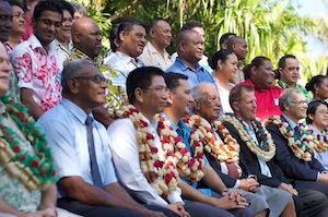
Rarotonga, Cook Islands 29/08/12 - At the 43rd Pacific Islands Forum meeting here in Rarotonga this week, a unique event was witnessed when the Leaders of seven (7) Pacific Island Countries signed and exchanged a total of eight (8) Maritime Boundary Agreements which will bring state-of-the-art accuracy and legal clarity to the boundary positions between several overlapping jurisdictions of neighbouring Pacific Island Countries.
This multiple signing event is a remarkable testament of the close kinship and excellent neighbourly relationships between Pacific Islands Countries and underlines their ability to work together in a spirit of equitable and unified progress. By clearly establishing these boundaries and zones under domestic and international law, as set out in the 1982 United Nations Convention on the Law of the Sea (UNCLOS), the signing of these agreements will provide the foundation for improved governance, protection, conservation and management of resources within respective national jurisdictions.
The seven (7) bilateral treaties were signed by the leaders of the Cook Islands, Niue, Kiribati, Tokelau, Tuvalu, Nauru and the Marshall Islands. In addition, the leaders of Kiribati, Marshall Islands and Nauru agreed to an additional tri-lateral treaty concerning the determination of a point where the Exclusive Economic Zones (EEZs) of all three (3) countries intersect, referred to as a “Tri-junction point”.
The successful preparations of these agreements leading up to the signing event have been a result of the excellent collaborative work between the respective technical and legal country teams and the regional coordination and collaboration with the Applied Geoscience & Technology Division (SOPAC) of the Secretariat of the Pacific Community (SPC), the Pacific Islands Forum Fisheries Agency (FFA), Geoscience Australia, the Government of Australia’s Attorney General’s Office and the Commonwealth Secretariat. The regional funding support towards these SPC activities is provided by AusAID.
Last Updated on Wednesday, 05 September 2012 10:25
Read more...
|
New Regional Legislative and Regulatory Framework for Deep Sea Minerals Launched
Wednesday, 29 August 2012 13:25
administrator
Rarotonga, Cook Islands Tuesday 29th August 2012: Cook Islands Deputy Prime Minister, the Honourable Tom Marsters today attended the release of the new Regional Legislative and Regulatory Framework for Deep Sea Minerals Exploration and Exploitation at the Pacific Island Leaders Forum currently underway here in Rarotonga, Cook Islands.
Marsters reflected that this Framework was called for by Pacific Leaders at their Forum in Cairns in 2009 as one of the key priorities of the Leaders Pacific Plan, during the period 2009 and 2012. In Cairns, Leaders called for the development of regional and national frameworks to enable the development of the economic potential of marine mineral resources; and strengthening regional and national capacity in the mining, environment, labour and financial sectors to comply with relevant standards for the deep-sea mining industry within the region, while supporting environmental monitoring that seeks to preserve fragile marine ecosystems and biodiversity.
This regional framework is the first in the Seabed Minerals sector and is the response to the Forum leaders call and is available now to guide Pacific island countries to prepare relevant national legislative and regulatory frameworks in the seabed minerals area.
Marsters said "the completion of this important framework and its release by SPC here at the 2012 Leaders Forum provides a key message from us gathered here for this Forum with the theme Large Ocean Island States: The Pacific Challenge".
Last Updated on Wednesday, 29 August 2012 13:27
Read more...
Precautionary Approach to Deep Sea Mineral Mining
Thursday, 23 August 2012 12:54
administrator

Exploring for deep sea minerals and possible exploitation in future presents an emerging new economic opportunity for Pacific Island countries. But this opportunity must be balanced against protection of the ocean environment and preservation of rare and fragile ecosystems and ocean habitats.
Dr Russell Howorth of the Secretariat of the Pacific Community (SPC) emphasised this point in his opening address at the Regional Training Workshop on Geological, Biological and Environmental Aspects of Deep Sea Minerals, saying that ‘the precautionary approach must prevail.’ Dr Howorth is Director of SPC’s Applied Geoscience and Technology (SOPAC) Division.
The workshop, held recently in Nadi, was organised by the EU-funded, SPC Deep Sea Minerals (DSM) Project and is part of the technical assistance provided to the 15 Pacific-ACP (African Caribbean and Pacific) states.
The 15 states are the Cook Islands, Federated States of Micronesia, Fiji, Kiribati, Marshall Islands, Nauru, Niue, Palau, Papua New Guinea, Samoa, Solomon Islands, Timor Leste, Tonga, Tuvalu and Vanuatu.
He said that DSM Project team members have already completed 13 national stakeholder consultation workshops across the region, with plans to visit the remaining two countries, Papua New Guinea and Timor Leste, in September.
Last Updated on Wednesday, 29 August 2012 13:28
Read more...
|
New Technologies Impact Pacific Planning
Thursday, 16 August 2012 10:24
administrator
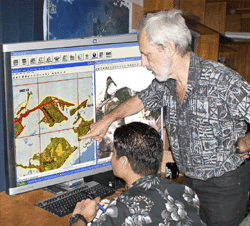
New technologies will change the way people live in Pacific Island countries. This is according to Dr Wolf Forstreuter, GIS and Remote Sensing Unit specialist at SOPAC, the Applied Geoscience and Technology Division of the Secretariat of the Pacific Community (SPC).
Dr Forstreuter said recent work to detect and analyse changes in vegetation on the Kiribati Islands of Aranuka and Maiana had important implications for all Pacific Islands.
“By overlaying recent satellite imagery on maps that were drawn from aerial photographs taken in 1969 of the Kiribati islands of Aranuka and Maiana, it is possible to detect any changes that have occurred,” he said.
“Not only can we assess the impact of people on the environment, we can assess whether this has been positive or negative. One of the surprises of this study was to discover that new mangrove areas are visible on the coast of both islands.”
Dr Forstreuter said this could be because of the 1969 photography-taking place during high tide, followed by misinterpretation by mapmakers in Britain.
“But the very real possibility is that the mangroves are increasing because they have been protected by the island’s inhabitants,” he said.
The comparison between the older maps overlaid with recent satellite images also shows the spread of settlements and changes to bodies of water.
“This information becomes a useful planning tool for the future. Where should settlements develop? What water is available for such development? Where and what types of farming should be planned to support these settlements?” he said.
Last Updated on Thursday, 16 August 2012 10:29
Read more...
Delivering Results for Water and Sanitation in Pacific Island Countries
Wednesday, 15 August 2012 15:16
administrator
Nadi, August 7, 2012: After three years of hard work Pacific Island countries are starting to deliver significant results under a regional project that was set up to address some of the most challenging water and sanitation issues in the Pacific.
The Global Environment Facility (GEF) funded Pacific Integrated Water Resources Management (IWRM) Project was launched in 12 countries in 2009 to protect vital watersheds, manage wastewater and sanitation, assess and protect water resources, and improve water efficiency and safety. The benefits of the work are now starting to be felt in the region.
“When we started out water and sanitation issues were dealt with sectorally, with agencies only focusing on their small part of a bigger problem and not communicating or working together in a coordinated and efficient manner,” Marc Wilson, Regional Project Manager for the GEF Pacific IWRM Project, said. “By demonstrating an integrated approach through tangible on-the-ground activities, we’ve seen a change in that. Not just in the localised area of the demonstration project but in many countries nationally, and also regionally.”
“For example in the Nadi Basin there was little consultation or long-term strategic planning between different sectors but the establishment of the Nadi Basin Catchment Committee (NBCC) has changed that. We now have all the key players around the same table discussing and making decisions on water management and flood reduction strategies and the Fiji Government is looking at replicating this model in other important catchments like Ba,” Mr Wilson said.
Last Updated on Wednesday, 15 August 2012 15:24
Read more...
|
|
|
|
|
|
Page 31 of 74 |


