


New technologies will change the way people live in Pacific Island countries. This is according to Dr Wolf Forstreuter, GIS and Remote Sensing Unit specialist at SOPAC, the Applied Geoscience and Technology Division of the Secretariat of the Pacific Community (SPC).
Dr Forstreuter said recent work to detect and analyse changes in vegetation on the Kiribati Islands of Aranuka and Maiana had important implications for all Pacific Islands.
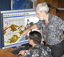
“By overlaying recent satellite imagery on maps that were drawn from aerial photographs taken in 1969 of the Kiribati islands of Aranuka and Maiana, it is possible to detect any changes that have occurred,” he said.
“Not only can we assess the impact of people on the environment, we can assess whether this has been positive or negative. One of the surprises of this study was to discover that new mangrove areas are visible on the coast of both islands.”
Dr Forstreuter said this could be because of the 1969 photography-taking place during high tide, followed by misinterpretation by mapmakers in Britain.
“But the very real possibility is that the mangroves are increasing because they have been protected by the island’s inhabitants,” he said.
The comparison between the older maps overlaid with recent satellite images also shows the spread of settlements and changes to bodies of water.
“This information becomes a useful planning tool for the future. Where should settlements develop? What water is available for such development? Where and what types of farming should be planned to support these settlements?” he said.
“Information gathered from satellite imagery can be used by Pacific Island governments and territories to find answers to such questions as they seek to improve the livelihoods of their citizens without destroying the fragile eco-systems around them.”
Caption: Dr Wolf Forstreuter (standing) and Mr Kataebati Bataua of SPC/SOPAC compare the 1970 map, to the left of the screen, with the recent satellite imagery seen to the right.

