Regional Agencies Work to Strengthen Environmental Management of Pacific’s Deep Sea Mineral Resources
Sunday, 08 December 2013 10:44
administrator

The Secretariat of the Pacific Community (SPC) and the Secretariat of the Pacific Regional Environment Programme (SPREP) are working closely together to consult stakeholders in order to identify and address concerns about the potential impacts of deep sea mining activities in the region.
As part of this ongoing work GSD, SPC’s Geoscience Division, is co-hosting a regional training workshop with SPREP on the environmental impacts of deep sea minerals activities from 9-13th December 2013 at the Tanoa International Hotel in Nadi, Fiji.
While no deep sea mining activities have yet taken place, this workshop is designed to collectively identify and assess national and regional environmental management needs and to develop a robust process for strengthened strategic planning and Environmental Impact Assessments (EIA’s) before any deep sea mining activities occur. Two government officials, one each from the environment and mineral development agencies of each of the 15 Pacific ACP States, and representatives from Civil Society have also been invited.
This workshop is part of the ongoing work of the SPC-EU Pacific Deep Sea Minerals Project to build national capacity and greater public awareness of the key issues related to the development and management of deep sea mineral resources in the Pacific.
Last Updated on Thursday, 19 March 2015 13:31
Read more...
Sea level station upgrades improve tsunami and climate preparedness
Wednesday, 13 November 2013 12:54
administrator
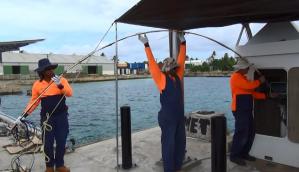
Tuesday, 12 November 2013, Secretariat of the Pacific Community (SPC), Suva, Fiji – On the old main wharf in Funafuti, Tuvalu, few passers-by normally stop to take note of the tall white hut that juts out over the lagoon. For the last two weeks, however, this hut- one of 14 similar dockside huts across the Pacific that monitor sea level and weather conditions- has been buzzing with activity as regional technicians work to upgrade the sensors, power, and data communications systems housed within.
The completion of this work in Tuvalu represents the successful conclusion of a 2-year project funded by the Australian Government to improve sea level and climate monitoring across the region.
‘The sea-level stations always collected data continuously, but only transmitted the data every hour,’ explains Stamy Criticos, logistics and installation manager from the Australian Bureau of Meteorology. ‘With the upgrade, the network of 14 stations are now transmitting every minute and will soon be able to provide real-time data to meteorologists around the Pacific. It will also be used to enhance tsunami tracking and warning systems.’
Known as the Observation Network Upgrade Project (ONUP), this project is boosting the capability of the Pacific Sea Level Monitoring Project, which has collected data from 14 sites across the Pacific since 1991. This data is used to understand sea-level changes and is frequently referenced for coastal development work, urban planning, tidal predictions, formulation of maritime boundaries, wave modelling and for navigational purposes.
Last Updated on Thursday, 19 March 2015 13:33
Read more...
|
Connecting The Pacific With Maps
Tuesday, 12 November 2013 14:20
administrator

12th November, 2013 – Around 150 Geographic Information System and Remote Sensing (GIS/RS) users and stakeholders from around the Pacific region will gather in Suva next week for the 2013 Pacific GIS/RS User Conference. The Conference runs from Monday 18th November to Friday 22nd November.
This year’s theme of the conference is “Connecting the Pacific with Maps”. Cutting edge advancements in GIS/RS technologies will be presented and discussed in-depth as well as an array of applications including the management of resources in small island Pacific nations.
GIS is a computer-based tool used to collect, combine and overlay information in the form of easily understood maps constructed from up-to-date satellite images and field data. Whereas, remote sensing is the collection of information from afar using sensors on aircraft, satellites, ships and other vessels. Together, the two can be used to make critical decisions about the physical and built environment.
The conference will be opened by Professor Michael Petterson, Director of Applied Geoscience and Technology Division, Secretariat of the Pacific Community (SPC).
“SPC recognises the power and versatility of GIS and its ability to combine, synthesise, model and present disparate geographical data sets. The demand for GIS and its applications to Pacific Development grows year on year. In a similar vein satellite and airborne data improves in quality and resolution at a frightening pace. The increasing usage of this powerful imagery and data allows rapid and accurate assessments of resources, land use, and environmental issues as never before. SPC is proud to be part of such a modern and forward looking meeting and welcomes all delegates to come and assist with the Pacific development agenda”, Professor Petterson commented.
Current and upcoming trends in the geographic technology fields such as LiDAR (light detection and ranging), Unmanned Aerial Vehicles (UAV), recent progress in vegetation and land cover mapping, improvements in satellite technologies, applications in disaster reduction and climate change adaption, web mapping and open source software will be discussed during the conference.
Last Updated on Thursday, 10 December 2015 09:57
Read more...
EU Funds Provincial Emergency Operation Centres in Solomon Islands
Friday, 08 November 2013 09:57
administrator
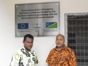
The new Western Province Emergency Operation Centre (EOC) was officially opened at Gizo on Friday 18 October 2013. Construction of the new EOC was made possible through funding from the European Union under the Disaster Risk Reduction Project (B-Envelope) implemented by the Applied Geoscience & Technology Division, Secretariat of the Pacific Community (SPC) based in Fiji.
In opening the building, Provincial Secretary and Acting Premier, Adrian Tony, stated that the Western Province is very much grateful for the assistance from the European Union in strengthening disaster management and the Provincial Government will ensure that the new EOC will be properly maintained to improve administration and coordination of disaster management.
He also stated that Western Province has recently experienced natural disasters with the recent tsunami that caused loss to property and human life and that the new Emergency Operation Centre will improve preparedness and reduce the risk to disasters.
The representative from SPC, George Beck, stated that Gizo is vulnerable to multi-hazards and the new EOC will provide a dedicated building from which to coordinate response to disasters as well as carry out their day-to-day operations.
He further stated that communities are already experiencing impacts to climate change and SPC is also working closely with the national Government to address important areas in policy and planning to reduce the risks to disasters.
Last Updated on Friday, 08 November 2013 10:09
Read more...
|