SPC Geoscience Division

Home News & Media Releases
News

Cook Islands Completes Maritime Boundaries Negotiations

E-mail Print PDF

Cook Islands is the first Pacific nation to complete negotiations with its neighbours on its maritime boundaries.

But it has taken several years to conclude the border treaties with states like Kiribati Niue and Tokelau and involved working closely with Geoscience Australia and the Applied Geoscience and Technology Division of the Secretariat of the Pacific Community.

Listen to the full interview

Speaker: Vaipo Mataora, Technical Adviser, Maritime Boundaries Project, Cook Islands

Source: Radio Australia, 27th March, 2014

Last Updated on Thursday, 10 December 2015 09:56
 

The Pacific explores the links between water and energy on World Water Day

E-mail Print PDF

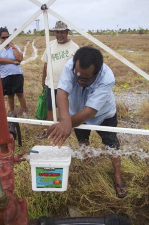
Did you know that 8% of global energy generation is used for pumping, treating and transporting water to various consumers?  Did you also know that most of the electricity generated in the Pacific Islands Countries and Territories is from water?

The links between these two scarce and important resources – water and energy – is the theme of this year’s World Water Day, celebrated globally on 22nd March.

Each year, World Water Day is acknowledged throughout the Pacific with the support of awareness materials prepared and distributed by the GSD Division of SPC.  This year’s theme draws attention to the vital role of water and energy sources to the sustainable development of Pacific Island Countries and Territories.

While energy is needed to pump, treat and distribute water to Pacific households, water is also an important energy source in several Pacific Island Countries, where the energy of rivers and streams is harnessed by hydro-electric facilities at the municipal, village and even household scale.

Solomone Fifita, head of the SPC Economic Development Division’s Energy Programme, noted the close linkages that exist between the conservation of water and energy resources.  “The choices we make every day on our water and energy use are closely related, and decisions on the supply, distribution, price and use of water and energy impact one another,” he said.
Last Updated on Thursday, 19 March 2015 13:27 Read more...
 

Post-Cyclone Rapid Assessment Assists Tongan Emergency Authorities

E-mail Print PDF

12 March 2014, Secretariat of the Pacific Community (SPC), Suva, Fiji – A rapid post-disaster assessment recently conducted by specialists from the Secretariat of the Pacific Community (SPC) will help Tongan emergency managers better understand the impacts of Cyclone Ian and prepare for future storms.

In early January, Cyclone Ian devastated parts of Tonga, particularly in the Ha’apai island group. The category-five storm killed one person, injured 14 others, displaced more than 4,000 people, and destroyed food crops and infrastructure.

In the wake of this storm, Tongan authorities requested assistance from SPC’s Geoscience Division (GSD) to assess damages on island of Lifuka in the Ha’apai Group.

‘They wanted us to provide technical data on the extent of inundation and erosion in coastal zones as well as water supplies and groundwater contamination in Lifuka,’ SPC Senior Technical Assistant and Oceanographer Zulfikar Begg explains. ‘They also asked us to train their geology staff so that they could do the same rapid assessments in the outer islands.’

Last Updated on Thursday, 19 March 2015 13:28 Read more...
 

First Annoucement: 2014 Pacific Platform For Disaster Risk Management & 20th Regional Disaster Managers Meeting

E-mail Print PDF

The Secretariat of the Pacific Community (SPC) and the United Nations Office for Disaster Risk Reduction (UNISDR) are pleased to announce the 2014 meeting of the Pacific Platform for Disaster Risk Management which will be held from 2nd – 4th June 2014 at the Novotel Hotel in Suva, Fiji. The Pacific Platform for Disaster Risk Management is the annual opportunity for Pacific island countries and territories, development partners and donors, civil society, private sector as well as other stakeholders to share experiences and knowledge in building the resilience of their communities to disasters. In addition, the SPC will also convene the 20th Regional Disaster Managers Meeting also at the Novotel Hotel from 5th – 6th June 2014.

In 2011, the Pacific islands region agreed to develop a Strategy for Climate and Disaster Resilient Development in the Pacific (SRDP) by 2015 to succeed the Pacific Disaster Risk Reduction and Disaster Management Framework for Action 2005 – 2015 and Pacific Islands Framework for Action on Climate Change 2006 – 2015. The new strategy will provide a new approach on how to efficiently address DRM and Climate Change within the context of risk resilient development. The process of developing this new strategy has become known as the ‘Roadmap’.

Last Updated on Monday, 03 March 2014 13:17 Read more...
 

Feedback: Strategy for Climate and Disaster Resilient Development in the Pacific (SRDP)

E-mail Print PDF

The Pacific Region is in the process of preparing a Strategy for Climate and Disaster Resilient Development in the Pacific (SRDP). The SRDP is at the forefront of the region's efforts to take a lead role globally in addressing climate change and disaster risk management in a more integrated manner.

WE NEED YOUR FEEDBACK!  A global consultation process is now underway and will close on the 3rd of March 2014. Please join this consultation to provide your comments and insights – we welcome feedback from everyone and you can provide as much or as little detail as you wish.

Visit www.pacificdisaster.net/srdp now to read a draft of the SRDP and provide your insights.

Last Updated on Wednesday, 26 February 2014 10:48


Page 14 of 74

Newsflash

“Geographical Information Systems and Remote Sensing is one of the fastest developing technologies no matter whether you are a provider, and developer or a user. And here in the region and for the benefit of Pacific island countries and territories we are all striving to stay at the ‘cutting edge of the technology.’  In this regard the theme of this Conference focusing on mapping Pacific resources is very timely”, said Dr. Russell Howorth, Director, SOPAC Division of SPC, in the opening keynote at the Pacific GIS/RS User Conference held at Suva last week.

The growing impact of GIS and Remote Sensing was very much evident by the record number of attendees and presentations at the conference. Around 300 participants, from the around the Pacific Region convened for the three and half days of presentations, workshops and discussions.

Current and upcoming trends in the geospatial fields such as LiDAR (light detection and ranging) Imagery, Unmanned Aerial Vehicles (UAV), recent progress in vegetation and land cover mapping, improvements in satellite technologies, imagery classification and open source software were heavily covered during the conference.

The conference has been held annually in Suva for the Pacific region since 1999, is free to attend and jointly organized by Secretariat of the Pacific Community, University of the South Pacific, various departments of the Fiji Government, with support from GIZ (Deutsche Gesellschaft für Internationale Zusammenarbeit), satellite data and GIS software companies.