


Tuesday, 12 November 2013, Secretariat of the Pacific Community (SPC), Suva, Fiji – On the old main wharf in Funafuti, Tuvalu, few passers-by normally stop to take note of the tall white hut that juts out over the lagoon. For the last two weeks, however, this hut- one of 14 similar dockside huts across the Pacific that monitor sea level and weather conditions- has been buzzing with activity as regional technicians work to upgrade the sensors, power, and data communications systems housed within.
The completion of this work in Tuvalu represents the successful conclusion of a 2-year project funded by the Australian Government to improve sea level and climate monitoring across the region.
‘The sea-level stations always collected data continuously, but only transmitted the data every hour,’ explains Stamy Criticos, logistics and installation manager from the Australian Bureau of Meteorology. ‘With the upgrade, the network of 14 stations are now transmitting every minute and will soon be able to provide real-time data to meteorologists around the Pacific. It will also be used to enhance tsunami tracking and warning systems.’
Known as the Observation Network Upgrade Project (ONUP), this project is boosting the capability of the Pacific Sea Level Monitoring Project, which has collected data from 14 sites across the Pacific since 1991. This data is used to understand sea-level changes and is frequently referenced for coastal development work, urban planning, tidal predictions, formulation of maritime boundaries, wave modelling and for navigational purposes.
For example, Ms Melina Ailesi, a technician and GIS officer for Tuvalu Telecom, reports that the sea level data is ‘the most important data’ she uses in her work. ‘I plan the network plan for our cables,’ she explains, ‘and tide data is very important to us. Funafuti experiences a lot of high tides every month and the most affected area is where our underground infrastructure is. That’s why I need this data, because if it’s high tide I can see how our assets are affected.’
When asked to comment on the sea level monitoring project, Permanent Secretary of Foreign Affairs Mr Tapugau Falefou notes that, ‘As decision makers, we need technical advice that is relevant, up to date, and accurate. Tuvalu is one of the most vulnerable countries to sea-level rise, and decisions based on inaccurate information can be disastrous to the country. I strongly see the importance of this project to be continued.’
The Australian Bureau of Meteorology’s Climate and Oceans Support Program in the Pacific (COSPPac) manages the sea-level monitoring project with technical and project support from the Secretariat of the Pacific Community’s Geoscience Division (GSD).
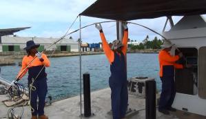
Caption: Bureau of Meteorology and SPC technicians install tide gauge system upgrades in Tuvalu.
For more information, contact Molly Powers (Tel: +679 338 1377; email: This e-mail address is being protected from spambots. You need JavaScript enabled to view it ) or visit the SPC website: www.spc.int.

