SPC refines links with the International Society for Photogrammetry and Remote Sensing (ISPRS)
Thursday, 21 August 2014 07:39
administrator

Prof. Christian Heipke during the discussion with GIS&RS users in Suva
The Secretary General of the International Society for Photogrammetry and Remote Sensing (ISPRS), Prof. Christian Heipke, met with the SPC Deputy Director, Fekitamoeloa Utoikamanu and SPC’s Geoscience Division Director Prof. Mike Petterson, last Friday to discuss further enhancement of the link between ISPRS and SPC-GSD.
ISPRS bundles national geospatial societies and through this, ISPRS has the largest network of research and method development in the geospatial area.
SPC-GSD has been the regional member for Pacific Island countries for the last 10 years with the rationale of using this network to benefit its member countries.
Last Updated on Thursday, 10 December 2015 09:53
Read more...
|
Water and sanitation a critical development issue for the Pacific
Wednesday, 20 August 2014 09:32
administrator

Water and sanitation are among the key challenges facing the Pacific Island region and will be a focus for discussion at the upcoming Third International Conference on Small Island Developing States (SIDS) in Samoa, 1‒4 September.
According to Mike Petterson, Director of the Secretariat of the Pacific Community’s (SPC) Applied Geoscience and Technology Division, all Pacific SIDS have made some progress in water and sanitation but not enough.
‘Many of these efforts are not keeping up with population growth, meaning the region as a whole is actually going backwards compared to the rest of the world,’ said Professor Petterson. ‘SPC is working with the World Health Organization (WHO) and UNICEF to assess progress against the Millennium Development Goal (MDGs) targets for water supply and sanitation. For the region as a whole the findings aren’t good.’
UNICEF Water, Sanitation and Hygiene Specialist, Marc Overmars, said the MDGs aim to halve the proportion of people without access to basic sanitation and safe drinking water by 2015. ‘The data we’ve collected with WHO suggest that for the Pacific as a whole, progress towards these targets has been poor compared to neighbouring regions and the world,’ he said.
Last Updated on Wednesday, 20 August 2014 09:37
Read more...
USA and Federated States of Micronesia formalise maritime boundaries agreement
Tuesday, 05 August 2014 09:52
administrator
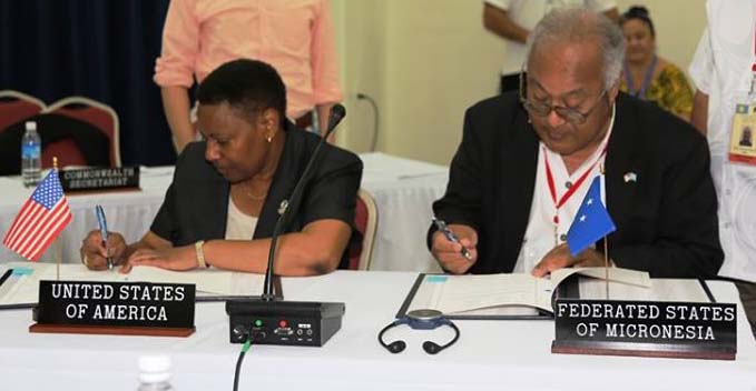
1st August 2014 – Secretariat of the Pacific Community – Koror, Palau: This morning, delegates to the 45th Pacific Islands Forum Leaders’ Meeting in Palau witnessed the signing of a maritime boundary treaty between the Federated States of Micronesia (FSM) and the United States of America (USA) to delimit the exclusive economic zones (EEZs) between the two countries. Signing the treaty on behalf of FSM was Secretary of Foreign Affairs Lorin Robert; the United States of America was represented by Deputy Assistant Secretary of State Dennise Mathieu.
The agreement, which has taken one and a half years to formulate, provides definitive legal status to the boundaries between the overlapping EEZs of FSM and the US Territory of Guam in the North Pacific Ocean.
This agreement underscores the importance of clearly establishing national areas of jurisdiction and limits under the 1982 United Nations Convention on the Law of the Sea (UNCLOS), which provides the foundation for improved governance, protection, conservation and management of national ocean resources.
The Secretariat of the Pacific Community, through its Applied Geoscience and Technology Division, assists member countries in this process in close coordination with a large consortium of partners who combine resources to deliver comprehensive service and expertise, including the Pacific Islands Forum Fisheries Agency, Geoscience Australia, the Commonwealth Secretariat, the United Nations Environment Programme (UNEP) GRID-Arendal centre, Australian Attorney General’s Office, and the University of Sydney.
The Pacific Islands region has approximately 48 shared maritime boundaries where neighbouring EEZs overlap. With the addition of this signed treaty, 32 of these boundaries are formalised and subject to treaty.
Last Updated on Thursday, 21 August 2014 08:36
Read more...
|
Understanding the Spatial and Temporal Occurrence of Landslides Using Satellite and Airborne Technologies: Papua New Guinea
Wednesday, 30 July 2014 15:07
administrator
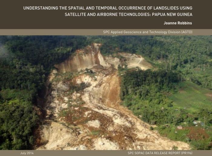
Data Release Report by Joanne Robbins
Landslides pose a significant threat to life and infrastructure in Papua New Guinea (PNG), with numerous movements being recorded annually. Such events are typically instigated by the combined effects of different geomorphological control factors, such as slope or geology, and the influence of a triggering event (i.e. an earthquake or heavy rainfall). Rugged topography and high seismicity combine in PNG, to make the region highly susceptible to large-volume, earthquake-induced landslides, while the climate encourages widespread rainfall-induced landslides. Of the two triggering mechanisms, understanding rainfall-induced landslide occurrence offers the best scope for early warning/forecasting system development, as meteorological models and data availability improve.
This paper presents an overview of research conducted to understand regionally-based, rainfall-induced landslide occurrence in PNG. Given the regional focus of this research and the need to develop a cost effective and reproducible methodology, pre-existing or freely available satellite and airborne data have been used. The aim of this research was to develop models capable of identifying rainfall events with the potential to trigger landslides, as well as models that distinguish areas of heightened landslide susceptibility from those with low/no landslide susceptibility. Together, these modelling approaches can be used to generate a broad-scale early warning/forecasting system, which could help to reduce the losses associated with landslides across PNG.
Last Updated on Tuesday, 05 August 2014 09:55
Read more...
GSD News 2nd Quarter: April - June 2014
Tuesday, 22 July 2014 11:15
administrator
Last Updated on Thursday, 19 March 2015 13:21
|
|
|
|
|
|
Page 10 of 74 |