


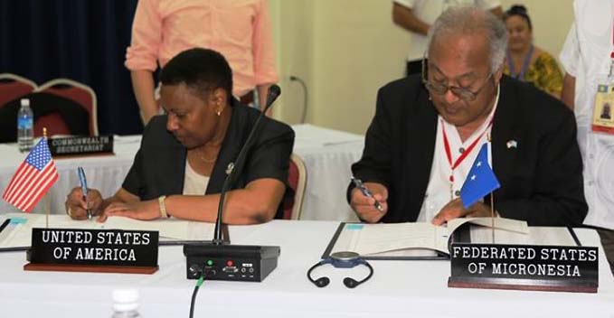
1st August 2014 – Secretariat of the Pacific Community – Koror, Palau: This morning, delegates to the 45th Pacific Islands Forum Leaders’ Meeting in Palau witnessed the signing of a maritime boundary treaty between the Federated States of Micronesia (FSM) and the United States of America (USA) to delimit the exclusive economic zones (EEZs) between the two countries. Signing the treaty on behalf of FSM was Secretary of Foreign Affairs Lorin Robert; the United States of America was represented by Deputy Assistant Secretary of State Dennise Mathieu.
The agreement, which has taken one and a half years to formulate, provides definitive legal status to the boundaries between the overlapping EEZs of FSM and the US Territory of Guam in the North Pacific Ocean.
This agreement underscores the importance of clearly establishing national areas of jurisdiction and limits under the 1982 United Nations Convention on the Law of the Sea (UNCLOS), which provides the foundation for improved governance, protection, conservation and management of national ocean resources.
The Secretariat of the Pacific Community, through its Applied Geoscience and Technology Division, assists member countries in this process in close coordination with a large consortium of partners who combine resources to deliver comprehensive service and expertise, including the Pacific Islands Forum Fisheries Agency, Geoscience Australia, the Commonwealth Secretariat, the United Nations Environment Programme (UNEP) GRID-Arendal centre, Australian Attorney General’s Office, and the University of Sydney.
The Pacific Islands region has approximately 48 shared maritime boundaries where neighbouring EEZs overlap. With the addition of this signed treaty, 32 of these boundaries are formalised and subject to treaty.
During the ceremony, Secretary Robert expressed gratitude to the Forum Secretariat and President of Palau for allowing the ceremony to take place during the meeting. He also said, ‘I take the honour as my high duty to represent President Mori and the FSM Government at this ceremony. Today's signing ceremony is indeed very important and timely given the theme of this year's forum -- Ocean: life and future. With a well-defined boundary between the United States Territory of Guam and the FSM now in place, today's occasion only confirms and strengthens the obvious. The obvious being the Micronesian tradition that we are peoples of the seas; we take pride in the stewardship and benefit from the bounties of the ocean.’
Deputy Assistant Secretary Mathieu said, ‘There is something special about boundary. Maritime boundaries promote good order at sea and peaceful relations between countries. But a boundary is also symbolic, and this boundary treaty reflects the important bonds of friendship between our two countries and the close relations between the people of the United States of America and the people of the Federated States of Micronesia.’ She added, ‘Working with FSM on this important endeavour was truly a pleasure for the US team. The US would like to extend its appreciation to the Federated States of Micronesia for the spirit of collaboration that guided the negotiation teams to this successful conclusion.’
This signing event marks another milestone as Pacific leaders continue their commitment to formalise unresolved maritime boundaries. The successful preparations of this agreement leading up to the signing event have been a result of the excellent collaborative work between the respective technical and legal country teams, which include the FSM Department of Foreign Affairs, Department of Justice and National Oceanic Resources Management Authority (NORMA) office, and the Office of the Legal Advisor and the Office of Oceans and Polar Affairs under the US Department of State.
Photo caption: US Deputy Assistant Secretary of State Dennise Mathieu, left, and FSM Secretary of Foreign Affairs Lorin Robert, signing the treaty in Palau
Source: US Embassy, Koror

