2012 Pacific GIS/RS User Conference - A Resounding Success
Friday, 07 December 2012 08:01
administrator

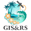
“Geographical Information Systems and Remote Sensing is one of the fastest developing technologies no matter whether you are a provider, and developer or a user. And here in the region and for the benefit of Pacific island countries and territories we are all striving to stay at the ‘cutting edge of the technology.’ In this regard the theme of this Conference focusing on mapping Pacific resources is very timely”, said Dr. Russell Howorth, Director, SOPAC Division of SPC, in the opening keynote at the Pacific GIS/RS User Conference held at Suva last week.
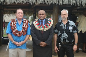
The growing impact of GIS and Remote Sensing was very much evident by the record number of attendees and presentations at the conference. Around 300 participants, from the around the Pacific Region convened for the three and half days of presentations, workshops and discussions.
Current and upcoming trends in the geospatial fields such as LiDAR (light detection and ranging) Imagery, Unmanned Aerial Vehicles (UAV), recent progress in vegetation and land cover mapping, improvements in satellite technologies, imagery classification and open source software were heavily covered during the conference.
The conference has been held annually in Suva for the Pacific region since 1999, is free to attend and jointly organized by Secretariat of the Pacific Community, University of the South Pacific, various departments of the Fiji Government, with support from GIZ (Deutsche Gesellschaft für Internationale Zusammenarbeit), satellite data and GIS software companies.
Last Updated on Wednesday, 06 February 2013 11:30
Read more...
Keynote Address - Dr Russell Howorth - 2012 Pacific GIS/RS Conference
Tuesday, 27 November 2012 16:02
administrator
Distinguished Guests, and Colleagues,
It is with much pleasure as Director of the SOPAC Division of the SPC that I present to you this morning the Keynote Address for this Conference, the largest of its kind in the region and which was set up to showcase new tools and concepts for improved data collection, capabilities and analysis in GIS and Remote Sensing. At the same time I would like to acknowledge Dr Jimmie Rodgers the Director General of the SPC who is unable to be here today and he gives his apologies.
Firstly, however it would be remiss of me if I did not take this opportunity to welcome all of you here this morning to the Opening of this Conference, and in particular I extend a welcome to all representatives of island governments and administrations, donor partner representatives, representatives of CROP organisations, educationalists, scientists and technologists from other stakeholder groups including NGOs. In particular I would like to highlight the many representatives from the private sector, including satellite data providers, image resellers, software and hardware companies. We have gathered here in the room a genuine mix of providers, developers and users.
Secondly, I would like to acknowledge that I have been privileged to address this conference over recent years and in that context I would like to acknowledge that having something different to say has never been difficult. GIS and Remote Sensing is one of the fastest developing technologies no matter whether you are a provider, and developer or a user.
On the global agenda the outcome of Rio+20 this year "The Future We Want" contains a particular paragraph of relevance:
274. We recognize the importance of space-technology-based data, in situ monitoring, and reliable geospatial information for sustainable development policy-making, programming and project operations.
And here in the region and for the benefit of Pacific island countries and territories we are all striving to stay at the "cutting edge of the technology." In this regard the theme of this Conference focusing on mapping Pacific resources is very timely.
Last Updated on Monday, 03 December 2012 10:25
Read more...
SOPAC 2 Meeting Outcome Statement Considered by CRGA 42
Friday, 23 November 2012 08:40
administrator
The second meeting of the Applied Geoscience and Technology Division (SOPAC) of the Secretariat of the Pacific Community (SPC) was held at the Jacques Iekawe conference hall at the SPC eadquarters in Noumea, New Caledonia, from 6 to 9 November 2012; and chaired by the representative of the Government of the Federated States of Micronesia. The meeting was preceded by the 9th Meeting of the Science, Technology and Resources Network (STAR).
The Chair's Outcome Statement from the SOPAC-2 meeting was considered by Committee of Representatives of Governments and Administrations (CRGA), a committee of SPC's governing body, which meets annually to discuss SPC’s work programme and governance issues. The 42nd meeting of CRGA was held at SPC headquarters in Noumea, New Caledonia on 12-16 November 2012.
Download the SOPAC-2 Chairs Outcome Statement that was considered by CRGA 42.
Last Updated on Tuesday, 23 April 2013 09:24
SPC assists countries with maritime boundary treaties and deep sea mining
Wednesday, 14 November 2012 14:36
administrator

The High Commissioner for Kiribati in Fiji, Ms Retata Nikuata-Rimon, yesterday thanked the Secretariat of the Pacific Community (SPC) for assisting her atoll nation with its maritime boundaries, hydrographic nautical charts and deep-sea mining.
On the latter, she said it was an area ‘in which there is growing interest as it offers potential for social and economic development, although we must be cautious about the environmental impact’.
Ms Nikuata-Rimon made these comments at the 42nd Committee of Representatives of Governments and Administrations (CRGA) meeting, which is being held at the SPC headquarters in Noumea from 12 to 16 November.
CRGA is a committee of SPC’s governing body, the Conference of the Pacific Community, which meets every two years.
Earlier this year, at the Forum Leaders’ meeting in Rarotonga, Cook Islands, seven Pacific Island countries and territories (Cook Islands, Kiribati, Nauru, Niue, Marshall Islands, Tokelau and Tuvalu,) signed and exchanged a total of eight maritime boundary agreements.
In addition, Kiribati, Marshall Islands and Nauru signed a trilateral treaty on the ‘Tri-Junction Point’, a point where the exclusive economic zones of all three countries intersect.
SPC’s Applied Geoscience and Technology Division supported the countries in the determination of the agreed boundaries, working collaboratively with members and with support from SPC’s Fisheries, Aquaculture and Marine Ecosystems Division and the Forum Fisheries Agency.
Agreement on boundaries has taken many years of work, often involving sensitive negotiations between members. The signing of these treaties has brought to just under 30 the total number of treaties concluded out of a total of 48 boundaries.
Last Updated on Friday, 16 November 2012 09:37
Read more...
|
New Start for the Pacific Islands GIS/RS Newsletter
Monday, 03 December 2012 10:13
administrator

More than two years ago we published the last Pacific Islands GIS/RS Newsletter. Now, we have a new team and will publish in regular intervals again. During the last few years changes have happened in the world of GIS and RS application as new type of data is available and also new software and hardware to handle it.
Essential is the new quality of space borne image data where satellites like WorldView-1, GeoEye and WorldView-2 have increased their geo-accuracy due to more precise position capture during data recording through enhanced on board GPS and star tracker.
Also the spatial resolution of these optical range satellites has further increased just that this is not delivered outside US. The increased radiometric resolution allows better stratification of vegetation; data of WorldView-2 now covers eight spectral bands where three visible and one near infrared was the norm before.
Last Updated on Friday, 07 December 2012 08:05
Read more...
Conference to Explore GIS Mapping
Friday, 23 November 2012 12:13
administrator
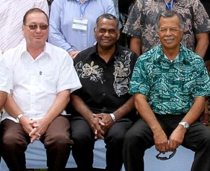
More than 150 delegates from around the world will meet in Suva next week (27) to participate in a GIS conference that will explore developments in this new science “that is already influencing the way we live our lives,” according to Wolf Forestrueter, SPC/SOPAC, Division Senior Officer GIS/RS Adviser
Held at the Holiday Inn, the 2012 Pacific Island Countries Geographic Information System (GIS) and Remote Sensing User (RS) Conference has chosen at its theme, “Mapping Pacific Resources” as an endorsement of the work undertaken in the region that profiles an array of applications including the management of resources of the small island Pacific nations.
GIS is a computer-based tool used to collect, combine and overlay information in the form of easily understood maps constructed from up-to-date satellite images and field data. Remote sensing is the collection of information about earth at a distance from aircraft or satellite.
“The GIS technology is already being used to map landslides, detect vegetation change, map town boundaries, map impacts of sea level rise. It has proven useful in the helping utilities and transportation better define their resources.
“The public might be more familiar with results closer to home where many smart phone applications and social media tools combine data with maps to deliver unique new services to consumers, Goggle Earth is an example,” said Mr. Forestrueter.
The four-day conference will feature GIS and remote sensing scientists and technicians to explore new developments and how they may apply to improving the lives of the people in region.
Last Updated on Tuesday, 27 November 2012 16:15
SOPAC Recognises World GIS Day
Friday, 16 November 2012 09:26
administrator
The World GIS Day, celebrated on 14th November every year, offers everyone a chance to learn more about the fascinating field of Geographic Information Systems and how GIS is part of our everyday lives today.
"Many young people are using GIS technology every day without even realising it. Many smart phone applications and social media tools combine data with maps to deliver unique services to consumers and Google Earth is known by most of us" advised Dr Wulf Killmann Team Leader of the SPC/GIZ project “Coping with Climate Change in the Pacific Island Region” and Dr Russell Howorth, Director of the Applied Geoscience and Technology Division of the Secretariat of the Pacific Community in a joint statement released to recognise World GIS Day.
GIS (Geographic Information Systems) are a set of computer-based tools used to collect, combine and overlay information in the form of easily understood maps constructed from up-to-date satellite images and field data, while remote sensing is the collection of information about the earth from a distance.
In the Pacific, GIS is now being used as a tool to map landslides, detect vegetation change, map town boundaries, map impacts of sea level rise and many more. GIS is quite useful in the area of utility, transportation, and might become a tool to model climate change.
Applied Geoscience and Technology Division (SOPAC) of Secretariat of the Pacific Community is the leading agency for GIS in the Pacific and hold images and GIS Data for its member countries and territories. SOPAC's primary goal is to apply geoscientific data and technology to realise new opportunities for improving the livelihoods of Pacific communities. SOPAC's work in GIS and remote sensing is supported by many partners including the German Government through the SPC/GIZ, Coping with Climate Change in the Pacific Island region.
While GIS practitioners around the world celebrates this day by holding workshops, seminars. The SOPAC division of SPC, supported by many partners, is working tirelessly to organise a conference held each year for all Pacific island countries and territories.
Last Updated on Sunday, 18 November 2012 15:43
Read more...
Snapshots 80: Disaster Reduction Programme: September - October 2012
Wednesday, 14 November 2012 14:22
administrator

Greetings to all our readers!
We creep ever so closely towards the end of the year and recently completed the annual milestone DRM gathering for the Pacific – the 2012 Pacific Platform for DRM in September. This year the annual Platform was combined with the Regional Water and Sanitation Consultations as a means to bring about a closer working relationship between the ‘Disaster’ and ‘Water and Sanitation’ communities in addressing the challenges of disaster and climate-related risk.
There is a special section in this edition on the 2012 Pacific Platform for DRM We may have turned the corner on the 2012 Pacific Platform but discussions have already started on the 2013 joint meeting of the Pacific Platform for DRM and the Pacific Climate Change Round Table. This will be a significant milestone event as we continue the work on the formulation of the integrated regional strategy for DRM and Climate Change which we plan to complete by 2015.
There is an interesting variety of stories in this edition covering some of our areas of work and I hope you’ll enjoy them.
Download Full Issue (1.7 mb)
Mosese Sikivou
Deputy Director
Disaster Redcution Programme
Last Updated on Wednesday, 14 November 2012 14:28
|