SPC Geoscience Division

Latest

Deep Sea Minerals Finance Workshop: Making sure the Pacific Islands are not left short-changed

E-mail Print PDF

Friday 9 May 2014, Secretariat of the Pacific Community (SPC) Suva, Fiji - Deep sea minerals have the potential to be a game changer for the Pacific. Whether they will bring a change for the good or the bad will be determined by the financial management of governments and their ability to adopt and enforce sensible environmental safeguards.

If revenue is managed transparently and prudently while protecting the environment, deep sea minerals could greatly improve the economies and livelihoods of the Pacific Islands countries.

To address these issues, the Secretariat of the Pacific Community (SPC) is holding a regional workshop, the fifth in its technical training series. This workshop will be held in Cook Islands on 13–16 May and will centre on the ‘Financial Aspects’ of the upcoming deep sea minerals industry.

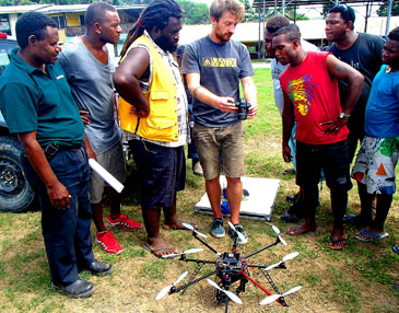
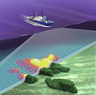
The workshop will bring together more than 60 Pacific Island government minerals and finance officials and experts from around the globe for the first regional event of its kind on managing the potential wealth generated from the extraction of deep sea minerals. Although deep sea mining is yet to occur world-wide, there is much commercial interest in mineral formations, such as nodules, crusts and seafloor massive sulphides that have been discovered on the seabed, thousands of metres below sea-level, particularly in the Pacific Ocean.

Last Updated on Thursday, 19 March 2015 13:37 Read more...
 

Water in Kiritimati: one step forward with EU Support

E-mail Print PDF

On 26 April 2014, Mr. Andris Piebalgs European Commissioner for Development, Mr. Tererei Aruee, Officer in Charge, Ministry of Line and Phoenix Islands Development, Government of Kiribati, and Mr. George Beck, representing the Secretariat of the Pacific Community (SPC), inaugurated the office for the EUR 4.8 million ‘Improving Drinking Water Supply in Kiritimati Island’ project.

“The European Union and Kiribati have forged a fruitful friendship over almost four decades. This initiative is a concrete example of our strong partnership and continued commitment to support the government of Kiribati and its people in their efforts towards attainment of the Millennium Development Goals”.

The representative from the Government of Kiiribati, Mr. Tererei Aruee stated that “water is an important priority of the Government and the rehabilitation of the reticulated water supply through this project will benefit the majority of residents on Kiritimati Island.

The Government appreciates the assistance of the European Union through this project and is committed to working closely with SPC in improving the reticulated water supply system.”

Mr. George Beck further added that “the focus will be to have a good understanding of the status of the ground water, building new infrastructure to improve supply to the Ronton community particularly the hospital and build capacity within the Ministry to monitor and maintain the water supply system.”

Last Updated on Thursday, 01 May 2014 10:00 Read more...
 

Secretariat of the Pacific Community brings drone technology to Solomon Islands

E-mail Print PDF

Tuesday 22 April 2014, Secretariat of the Pacific Community (SPC), Honiara – Staff of SPC's Solomon Islands Country Office were saddened to witness the human tragedy of the recent floods. The loss of life when the Mataniko and other rivers burst their banks and the old Mataniko bridge collapsed highlighted the plight of poor squatters with little choice but to occupy land that regularly floods.

Country Office Manager, Mia Rimon, contacted SPC Director-General Dr Colin Tukuitonga and the Director of SPC's Applied Geoscience and Technology Division (AGTD) Mike Petterson with a request for assistance. A request came also from the Solomon Islands Ministry of Lands, Housing and Survey (MLHS) to provide a geohazards assessment.

SPC responded to these appeals for help; the AGTD Director arrived in Honiara with his team and met with the permanent secretaries of the Ministry of Foreign Affairs and External Trade, MLHS and the Ministry of Energy, Mines and Rural Electrification (MEMRE). They presented unmanned aerial vehicle (UAV, or drone) technology to the government to obtain precise imagery of the flooded areas.

Last Updated on Monday, 28 April 2014 07:53 Read more...
 

GSD News - 1st Quarter : January to March, 2014

E-mail Print PDF

Read Online

Download (5.7mb)

Last Updated on Thursday, 19 March 2015 13:24
 

Surveys underway to update Vanuatu navigational charts

E-mail Print PDF

9 April 2014, Secretariat of the Pacific Community (SPC), Suva, Fiji – Work begins next week on a series of underwater surveys to produce updated navigational charts for Vanuatu.  Like many Pacific Island countries, Vanuatu has a vast maritime area. Modern charts will result in safer navigation for both cargo shipping and cruise ships, producing economic and social benefits for Vanuatu.

A team of hydrographers and technicians from the Government of Vanuatu and the Secretariat of the Pacific Community’s Geoscience Division (GSD) will collect the necessary data over several months.  Their supported by the New Zealand government, the United Kingdom’s Hydrographic Office, and the Government of Vanuatu.

The survey will chart four critical areas which have been identified through a risk assessment carried out by New Zealand – Luganville and Champagne Bay on Espiritu Santo, and the islands of Wala, Malekula, and Homo Bay, Pentecost.

‘The port of Luganville in particular is of high economic value to Vanuatu,’ says Mr Jens Kruger, Acting Deputy Director of SPC’s Geoscience for Development Programme. ‘The current chart from this port relies mostly on 19th century data and no new information has been added to the chart since the Second World War.’

Starting in July 2014, the International Maritime Organisation’s Safety of Life at Sea Convention regulations will require member countries to move toward using electronic navigational charts in their regions for safe shipping reasons.

Last Updated on Thursday, 19 March 2015 13:25 Read more...


Page 13 of 74

Newsflash

“What is an absolute necessity is these Geographic Information System (GIS) and Remote Sensing (RS) tools are developed in an integrated and strategic manner for all those involved in these technologies.”

Dr. Howorth, the Director of the SOPAC Division of the SPC, was addressing the first Solomon Islands National Geographic Information System (GIS) and Remote Sensing Stakeholder Meeting as its keynote speaker.

He said that the goal of the SOPAC Division is to apply geoscience and technology to realize new opportunities for improving the livelihoods of Pacific communities. GIS and Remote Sensing is clearly a technology that can contribute to realizing improving livelihoods.

GIS is a computer-based tool used to collect, combine and overlay information in the form of easily understood maps constructed from up-to-date satellite images and field data, while Remote Sensing is the collection of information about the earth from a number of sources that could utilize satellites, aircraft, or electromagnetic radiation.

Dr. Howorth told the participants that Pacific islands share much in common and the Solomon Islands is no exception.