 Ten years of research has culminated in the Banaban Report, a detailed study of phosphate mining on the Kiribati atoll island of Banaba (Ocean Island).The report, produced by SOPAC and commissioned by the Kiribati government, was presented to its President Anote Tong in a special ceremony in Suva recently. SOPAC is a division of the Secretariat of the Pacific Community (SPC).
In presenting the report, SOPAC’s Director, Dr. Russell Howorth said that the contents were a milestone of achievement. “The challenges of sustaining such work over the long period of time is an endorsement of both Kiribati and SOPAC’s partnership commitment to the project,” said Dr. Howorth.
Joining Dr. Howorth at the presentation was SPC’s Deputy Director General, Mrs. Fekita ‘Utoikamanu, who said that SPC would investigate the use of its wider resources to further develop the resources on Banaba Island as an extension of the report.
President Tong accepted the report on behalf of the Kiribati government and thanked SOPAC for all the support it has given “to his country over the years.”
Caption: Kiribati President Anote Tong (left) receives the Banaban Report from SOPAC Director Dr. Russell Howorth (right), while SPC Deputy Director General (centre) Mrs. Fekita ‘Utoikamanu looks on.
Kiribati receives phosphate report on Banaba Atoll


|
||
|
||
|
|
||
| Page 57 of 74 |
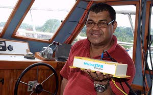 SOPAC has introduced a navigational positioning service into the region that could make a major contribution in improving the safety of lakes, rivers and the ocean, according to Robert Smith, SOPAC’s Senior Advisor Marine Geophysics, SOPAC is a division of the Secretariat of the Pacific Community (SPC).
 From The Managers Desk
 A four-year regional Deep Sea Minerals (DSM) Project has been designed to address the policy and law requirements of Pacific Island Countries. This is in relation to the potential mineral wealth on the seabed within their respective country’s waters.
 Wednesday 16th February, 2011, Secretariat of the Pacific Community (SPC), Nouméa, New Caledonia. The Government of New Caledonia and the Secretariat of the Pacific Community have signed three agreements today to fund interventions to reduce public health risks resulting from contaminated drinking water, inadequate sanitation and drought.
Newsflash
|
Suva, Fiji – A major regional geospatial information system and other innovative risk assessment tools are being developed to assist Pacific Island countries to undertake evidence-based decision making in development planning and finance. A four-day workshop, running from 9 to 12 June 2015, opened in Suva today with representatives from Pacific region governments and development partners attending, focusing on the disaster risk modelling and assessment tools. The tools, including a rapid impact estimation tool and the Pacific Risk Information System (PacRIS), are being developed by the Secretariat of the Pacific Community (SPC), World Bank and the Asian Development Bank with the financial support of the Government of Japan and the Global Facility for Disaster Reduction and Recovery (GFDRR). “These tools can be used to improve the resilience of Pacific Island countries by providing the technical information needed to make informed decisions about risk of disasters to communities and their assets,” the Director of SPC’s Geoscience Division, Professor Michael Petterson, said. |


