Safe navigation gets boost in region
Sunday, 01 May 2011 19:01
administrator
 The safety of navigation and the protection of the marine environment in the region took a positive step forward recently with the signing of a Memorandum of Understanding between the International Hydrographic Organization (IHO) and Secretariat of the Pacific Community (SPC). Hydrography is the study, surveying, and mapping of the oceans, seas and rivers, especially related to navigation and the environment. The safety of navigation and the protection of the marine environment in the region took a positive step forward recently with the signing of a Memorandum of Understanding between the International Hydrographic Organization (IHO) and Secretariat of the Pacific Community (SPC). Hydrography is the study, surveying, and mapping of the oceans, seas and rivers, especially related to navigation and the environment.
IHO is comprised of 80 member governments represented by their respective national hydrographic offices. Its objectives include the standardization of nautical charts as well as the adoption of reliable and efficient methods to conduct hydrographic surveys.
Last Updated on Tuesday, 03 May 2011 10:32
Read more...
Meeting highlights political will to improve water and sanitation in Micronesia
Monday, 18 April 2011 16:27
administrator
In mid-April Micronesian countries met for the first time in Majuro, The Republic of the Marshall Islands (RMI), to look at ways to improve water and sanitation throughout the region.
Delegates from Palau, Guam, the Federated States of Micronesia, and RMI gathered to establish a Micronesian Water Committee, as a permanent working group of the Micronesian Chief Executives Summit’s (MCES).
In opening the meeting, RMI’s Acting President, Mr Ruben R. Zackhras, said that the fast pace of urbanization had led to tremendous pressure on demand for water and sanitation and that in many countries water had to go from being an abundant resource to one of scarcity. He also reminded delegates that globally water resources are in crisis.
Last Updated on Monday, 18 April 2011 16:32
Read more...
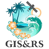
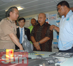
Cutting-edge research surveys seabed minerals in Tongan EEZ
Wednesday, 13 April 2011 09:29
administrator
 12 APRIL 2011 NUKU’ALOFA (GOVERNMENT OF TONGA) - A Korean research vessel will carry out scientific studies on seabed minerals in Tongan waters over the next several months. 12 APRIL 2011 NUKU’ALOFA (GOVERNMENT OF TONGA) - A Korean research vessel will carry out scientific studies on seabed minerals in Tongan waters over the next several months.
The IBRV Araon arrived 9th April with the aim of investigating seabed massive sulphide deposits such as copper, silver and gold in Tonga’s Exclusive Economic Zone.
At a special ceremony to welcome the new ship on Friday, Deputy Prime Minister Samiu Kuita Vaipulu, in his role as Acting Prime Minister, thanked the Korean Ocean Research and Development Institute (KORDI) for organising the visit.
Last Updated on Wednesday, 13 April 2011 09:40
Read more...
Map updates a challenge for Pacific Island countries
Tuesday, 29 March 2011 13:57
administrator
 Pacific Island countries and territories are challenged by the necessity to update their maps to reflect the current day realities. “Countries are utilising several mapping systems, or projections, in parallel,” explained Dr Wolf Forstreuter, SOPAC’s Remote Sensing and Geographic Information Systems (GIS) Specialist. SOPAC is the Applied Geoscience and Technology Division of the Secretariat of the Pacific Community (SPC). Pacific Island countries and territories are challenged by the necessity to update their maps to reflect the current day realities. “Countries are utilising several mapping systems, or projections, in parallel,” explained Dr Wolf Forstreuter, SOPAC’s Remote Sensing and Geographic Information Systems (GIS) Specialist. SOPAC is the Applied Geoscience and Technology Division of the Secretariat of the Pacific Community (SPC).
“For example, road networks river systems, coastlines, contour lines and village locations are available on different maps. Often each has different accuracy and a different projection. They do not overlay or fit one on top of the other,” continued Dr Forstreuter.
Dr Forstreuter said that discrepancies are the result of several factors: the mapping carried out by the first surveyors at the end of the 19th century; tectonic shift, which contributes to islands shifting position; legal challenges associated with using old maps, and the need for Lands Departments to move to the use of remote sensing data and new software.
Last Updated on Tuesday, 29 March 2011 14:01
Read more...
|
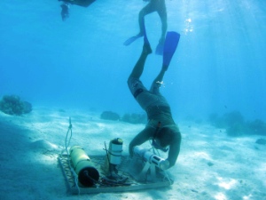
Deep sea mineral survey licence for institute
Wednesday, 27 April 2011 15:44
administrator
 The Korea Ocean Research and Development Institute (KORDI), rated among the world’s top ten such research institutions, is ready to explore Fiji’s deep sea mineral wealth. The Korea Ocean Research and Development Institute (KORDI), rated among the world’s top ten such research institutions, is ready to explore Fiji’s deep sea mineral wealth.
After the issue of its deep sea mineral exploration licence by the Ministry of Lands and Mineral Resources late last month, its survey ship ARAON is now docked at the Kings Wharf in Suva.
The institute is keen to explore the Lau Basin after polymetallic sulphide deposits were discovered in the area.
Source: Fiji Sun, 27th April, 2011
Last Updated on Sunday, 01 May 2011 19:15
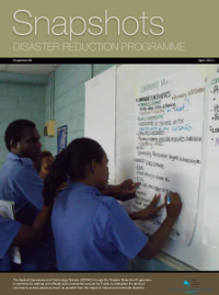
Snapshot 67 - Disaster Reduction Programme - March 2011
Friday, 15 April 2011 11:50
administrator
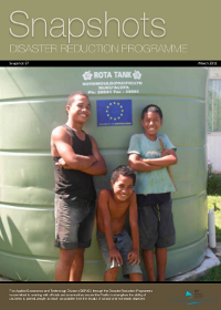 Another month and unfortunately another major devastating event. We must all take a moment to remember those whose lives have been changed forever by the earthquake and tsunami that ravaged northeaster Japan earlier this month. The tragedy is quite immense and each day we hear and see stories that remind us of why we work in this area of disaster risk management. Another month and unfortunately another major devastating event. We must all take a moment to remember those whose lives have been changed forever by the earthquake and tsunami that ravaged northeaster Japan earlier this month. The tragedy is quite immense and each day we hear and see stories that remind us of why we work in this area of disaster risk management.
In the region there have been a number of interesting developments as this issue of Snapshots will portray. In Papua New Guinea we’re into the home stretch in relation to a DRM Action Plan for Morobe Province. The work on this started last year and Waisale Naqiolevu, our man on the ground has an interesting piece on this.
Last Updated on Friday, 15 April 2011 11:54
Read more...
Improvements to mapping low-lying Pacific islands
Saturday, 02 April 2011 15:27
administrator
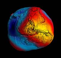 A fairly important development for Pacific islands mapping initiatives has occurred because of the results of the recently concluded European Space Agency GOCE (Gravity field and steady-state Ocean Circulation Explorer) mission. A fairly important development for Pacific islands mapping initiatives has occurred because of the results of the recently concluded European Space Agency GOCE (Gravity field and steady-state Ocean Circulation Explorer) mission.
The primary result of the GOCE mission is the “most accurate model of the geoid ever produced”. This new and improved data will eventually be incorporated into GPS software of the future and hopefully eliminate the need to devise complicated new national projections to arrive at “real” height readings for any point, when measured with current GPS equipment.
Last Updated on Saturday, 02 April 2011 15:32
Read more...
RMI Water Summit ends with a plan to move forward
Wednesday, 23 March 2011 19:07
administrator
Majuro, March 23, 2011 - Water is obviously a real concern for many people here in the Marshall Islands as hundreds gathered at the RMI International Convention Centre over two days this week to participate in the first ever National Water Summit.
The summit looked at some of the most pressing water issues facing the RMI including: water availability, distribution, quality, and management. Most participants also wanted to know what government is doing to resolve these issues and if there is a plan to better manage water.
The President, His Excellency Jurelang Zedkaia, when opening the summit urged participants to find practical ways to work together to solve water issues and urged all Marshallese to take personal responsibility for this vital resource.
Last Updated on Wednesday, 23 March 2011 19:10
Read more...
|


 The EU EDF 9 B Envelope Project is really making some great strides as we demonstrate in this issue. The Federated States of Micronesia will have Emergency Operations Centres at state level and Chuuk is the first state to complete construction. In addition to this we are continuing with our training programme with the leadership and support of The Asia Foundation/USAID Office of Foreign Disaster Assistance and also continuing support for the developing of Joint DRM and CCA National Action Plans.