


 Pacific Island countries and territories are challenged by the necessity to update their maps to reflect the current day realities. “Countries are utilising several mapping systems, or projections, in parallel,” explained Dr Wolf Forstreuter, SOPAC’s Remote Sensing and Geographic Information Systems (GIS) Specialist. SOPAC is the Applied Geoscience and Technology Division of the Secretariat of the Pacific Community (SPC).
“For example, road networks river systems, coastlines, contour lines and village locations are available on different maps. Often each has different accuracy and a different projection. They do not overlay or fit one on top of the other,” continued Dr Forstreuter.
Dr Forstreuter said that discrepancies are the result of several factors: the mapping carried out by the first surveyors at the end of the 19th century; tectonic shift, which contributes to islands shifting position; legal challenges associated with using old maps, and the need for Lands Departments to move to the use of remote sensing data and new software.
By the end of the 19th century, surveyors had already developed grid systems covering large parts of Europe. When the first mapping of island countries took place, a grid system was created for each island that had no reference point to any existing maps, as there were no orientation points to link to another point of an existing mapping system.
“Often legal ownership is based on these old maps and old systems,” said Dr Forstreuter.
Dr Forstreuter further explained that islands are not stable, but are moving, due to two different reasons. The first reason is when there is tectonic shift, an effect that is visible in Tonga, or the very recent case of Japan when the whole country shifted two metres within a few hours. Secondly, the coastal ocean currents can drift sand away from one side of a small island and settle it on another side.
“Today, previously existing land parcels on one side of an island may be in the ocean, while on the other side new land exists without ownership. Often Lands Departments deal with maps where land parcels do not fit the actual river system, or with maps where the island has drifted away,” said Dr Forstreuter.
“To address these land shifts and find a permanent solution presents an enormous challenge, not to mention workload, for countries’ Lands Departments.
“Land ownership and land parcel boundaries have high legal and cultural value in Pacific Island Countries and Territories. Once maps have been stamped and declared legal, they remain in force, even if details, such as river systems, are incorrectly marked,” said Dr Forstreuter.
A related issue in many Pacific Island Countries and Territories is that Global Positioning Systems (GPS) equipment is not recognised as legal surveying equipment, “…despite the accuracy that satellite technology makes available. Consequently, surveys have to be carried out in traditional ways, supported by the analysis of aerial photography,” explained Dr Forstreuter.
Traditionally, Lands Departments have been the only source of mapping in a country, used by other government departments such as Forestry, or utility organisations such as an electricity companies.
Dr Forstreuter said that since the year 2000, space borne image data, or satellite imagery, has been available for mapping at a scale of 1:10,000, and that GIS and image data software have become so user friendly that it is not necessary to have a background in surveying to use these.
Satellite sensors work in way similar to a photocopier, so that the image is not distorted. The user can map on the computer screen immediately using satellite information and images.
In the past there has been the tendency for donor assistance to countries’ Lands Departments to reinforce old technology rather than establish facilities for the analysis of space borne image data.
Therefore other departments and organisations have created their own faster and more efficient mapping facilities, using the new technologies.
To ensure that all surveys carried out using GIS software, image analysis software and GPS related software work properly the projection of a country using the international grid needs to be installed.
Dr Forstreuter said that international grids might be difficult to apply to low-lying Pacific Island Countries and Territories as sea levels follow locational gravity, not an idealised worldwide ellipsoid. In these cases the height indicated on the map is not related to mean sea level. However, this can be overcome with correct geodetic knowledge, as has taken place in Tonga and Samoa, which now have new grid systems. END
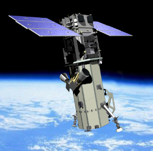
Photo Caption: The satellite WorldView 2 has been in space for one year, and provides images with 0.5 metre resolution and allows creating thematic maps of 1:5,000 scale.

