


Monday 17 June 2013, Secretariat of the Pacific Community (SPC) – The Secretariat of the Pacific Community (SPC), with Geoscience Australia, has developed a computer model to help the Government of Tonga see what the impact of a tsunami would be on Tongatapu. Part of an AusAID funded project, the model makes use of high resolution data, the collection of which was made possible by Australia, the European Union, and the New Zealand Ocean Sciences Grant.
The new Tsunami Inundation Model shows that an 8.7 magnitude earthquake in the Tonga Trench would create a wave that would hit the eastern coast of Tongatapu within ten to twenty minutes, inundating most of Nuku’alofa. Leveni ‘Aho, Director of Tonga’s National Disaster Management Office, says the new computer model has enabled the Government of Tonga to consider how the public would need to respond in a range of possible scenarios.
‘Nuku’alofa has, perhaps, the biggest urban population in the Pacific living in a very low-lying area. We can talk about Japan’s earthquakes but if we can present something that shows what is going to happen to us here at home, the message is much more effective. For us, it’s an excellent opportunity to help communities to be aware of what could possibly come and what they will need to do if a significant event occurs,’ he says.
After the model was presented to the cabinet and the National Emergency Management Committee, the Hon. Prime Minister Lord Tuʻivakanō indicated that the government would need support to construct access ways to some parts of Nuku’alofa so that the local community can quickly get to safe areas.
Mr ‘Aho says the model is also helping the Government of Tonga to design emergency response measures and improve long-term urban planning for Nuku’alofa and its surrounding villages.‘The tsunami computer model given by SPC has provided the government with a wonderful tool to help us really understand the risks of different scenarios and to prepare in the best ways we can,’ he says.
Mosese Sikivou, Deputy Director of SPC’s Disaster Reduction Programme, says this project is part of SPC’s assistance to Tonga in connection with its Joint National Action Plan for Climate Change Adaptation and Disaster Risk Management, approved by Cabinet in July 2010. The work to develop the model is part of an integrated approach that SPC and other partners are taking right across the Pacific to try and maximise scarce resources and minimise duplication of effort and potential conflict in policy development.
‘The new information provided by the tsunami model is helping the Government of Tonga to make plans to prepare for possible tsunami events, and it is also helping to inform longer-term decisions about whether to relocate homes and infrastructure away from low-lying areas. It is clear that these important planning decisions will also help to protect these communities from the effects of projected sea level rise,’ he says.
He adds, ‘At community level, there is little practical difference between disaster risk reduction and climate change adaptation. They both aim to reduce the vulnerability of communities and contribute to sustainable development.’
Recognising this, the Pacific will achieve a global first when the two main regional conferences – the Pacific Platform for Disaster Risk Management and the Pacific Climate Change Roundtable – convene a joint meeting in Nadi, Fiji in July 2013.
The outcomes of this meeting, organised by SPC, The Secretariat of the Pacific Regional Environment Programme (SPREP) and The United Nations Office for Disaster Risk Reduction (UNISDR), will feed into the development of a Pacific integrated regional strategy for disaster risk management and climate change.
Mr Sikivou says that SPC’s commitment to integrate climate change adaptation and disaster risk management will help Pacific Island countries to improve the way they identify and manage a range of risks that their communities are exposed to.
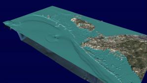
Caption: The first frame shows what the terrain around Nuku’alofa would look like if all the water was removed from the ocean. Initially, large areas of Nuku’alofa would potentially be below sea level (in blue) as a result of subsidence caused by the earthquake. The model predicts a first wave would hit Nuku’alofa in about 25 minutes after the earthquake, generating a ~2.5 m water level rise at the coastline. A second wave would then hit about 40 minutes after the earthquake at a height of about 4 to 5 m at the coastline. The model predicts that many smaller waves would continue hitting Nuku’alofa for the next few hours.
Still frames from model animation can be downloaded from http://www.mediafire.com/folder/d12ixwway4dd6/Tongatapu_Tsu_frame
For more information please contact Steve Menzies at:
This e-mail address is being protected from spambots. You need JavaScript enabled to view it
or
This e-mail address is being protected from spambots. You need JavaScript enabled to view it

