


Local pilots play an important role in the safe passage of container ships and other large vessels into and out of Pacific ports. Foreign shipmasters rely on pilots for their local knowledge of depths, currents, locations of wrecks, reefs, navigation aids, and other potential obstacles. And now, updated oceanographic studies of Suva Harbour’s sea floor and currents are being used to localise and improve a computer-simulated training for ships’ pilots in the Pacific region.
A recent collaboration between two divisions – the Economic Development Division (EDD) and the Applied Geoscience and Technology (SOPAC) Division – of the Secretariat of the Pacific Community (SPC) has produced the first simulation of a Pacific Island port.
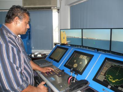
According to SPC Shipping Advisor John Rounds, the computerised simulator is a critical training tool because it can test a pilot’s ship-handling competence under a variety of challenging wind and sea conditions without the expenditure and risk of practising on actual vessels. ‘It’s like a blown up computer game,’ he says.
SPC’s EDD has hosted simulated training for pilots since 2004, but the simulations were all of foreign ports such as Sydney, Singapore, and London. This year, however, with data provided by SOPAC Division on Suva Harbour tides, currents, and bathymetry, pilots can practise entering and exiting a major Pacific Island port.
‘It’s just like being on the bridge of a big vessel entering the Suva Harbour,’ reports SPC Maritime Systems Development Advisor Megan Streeter. ‘The wheel handles the same, the radar is the same.
‘And the simulator can be adjusted to simulate ships of different sizes in different weather conditions. Many Pacific pilots haven’t had much exposure to large vessels, so this allows them to make mistakes in a risk-free environment,’ she adds.
According to Streeter, the SOPAC studies have also identified and included in the simulation additional wrecks not found in nautical charts.
‘These steps will help Pacific countries to standardise pilot training and improve port safety in line with International Maritime Organization guidelines,’ says Tongan Captain Hakaumotu Fakapelea. ‘If you train as a pilot in New Zealand, you train on New Zealand ports. We need to recognize our local knowledge.’
One of Suva’s most senior pilots, Captain Malcolm Peckham, participated in a regional pilot training in April. ‘I have been dreaming of this to happen,’ he said of the Pacific-focused training materials and simulation.
SPC hopes to be able to develop simulations of other Pacific Island ports as oceanographic data become available.
ENDS
For more information, contact Megan Streeter (Tel.: +679 337 0733 ext. 35278 ; email:
This e-mail address is being protected from spambots. You need JavaScript enabled to view it
) or visit the SPC website: www.spc.int
Caption: Captain Leatuaoa Sakaria, a navigation lecturer at the Samoa National University School of Maritime Training, test drives the simulator.

