
Friday 11 July 2014, Secretariat of the Pacific Community (SPC) headquarters, Noumea, New Caledonia – The Secretariat of the Pacific Community (SPC) geographic information systems (GIS) and remote sensing team has received two awards from the world’s leading supplier of satellite imagery, DigitalGlobe Inc., based in Colorado, USA.
They received a Partner Excellence Award 2014 for increased sales volume and meeting business growth expectations. SPC is the only authorised reseller of DigitalGlobe products in the Pacific Island region.
SPC members currently receive the highest-resolution satellite image data commercially available at some of the lowest prices on the planet.
Speaking at the awards ceremony held at SPC’s Suva Regional Office on Thursday 10 July, 2014 Wolf Forstreuter, GIS and Remote Sensing Specialist, explained emerging fields in the application of satellite imagery data.
‘Emily Artack, our Maritime Boundaries Technical Officer, used satellite image data for determination of maritime boundaries between Kiribati and Marshall Islands. This is a new application for satellite image data. And it is the first time that the International Seabed Authority has recognised satellite imagery as a legal tool to determine boundaries.’
Successive technical innovations have put SPC’s GIS and remote sensing team at the forefront of international application of satellite image data and cemented its place in a value-adding service chain that benefits people right across the region. ‘We are applying very sophisticated data to real development needs,’ says Petterson.
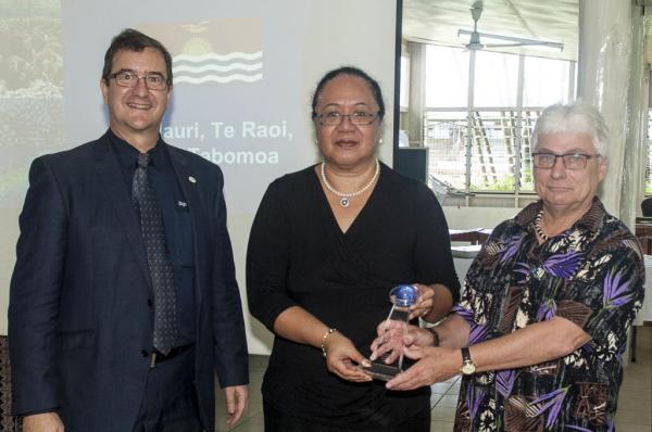
A large number of staff turned out to watch as Fekitamoela ‘Utoikamanu, SPC Deputy Director-General, received the awards from Peter Kinne, Regional Director for DigitalGlobe.
A statement from Takayuki Odawara, DigitalGlobe’s Vice President of Asia-Pacific Commercial Sales, emphasised that ‘the achievements of such a small group have been world class.’ The statement went on to say, ‘These awards recognise the excellence of the work performed and the efforts of the GIS and remote sensing team.’
Satellite imaging technology has a variety of applications in the Pacific, including forestry, land use planning, agriculture, geology, fisheries, port operations, disaster management, infrastructure and urban planning, maritime boundaries, biodiversity conservation, climate change adaptation, and education. It also permits Pacific Island countries to replace long-outdated aerial maps and cartographic data.
For more information, contact Wolf Forstreuter, GIS and Remote Sensing Specialist, +679 927 2462, This e-mail address is being protected from spambots. You need JavaScript enabled to view it
Background information:
SPC is an intergovernmental development organisation that supports Pacific Island countries and territories, through its broad scientific and technical expertise, in achieving their development goals. It has 26 members comprising 22 Pacific Island countries and territories and Australia, France, New Zealand and the United States of America.