


Tuesday, 24 September 2013, Secretariat of the Pacific Community (SPC), Suva, Fiji – Regional experts in land and marine survey and management commended the work of the AusAID-funded Pacific Sea Level Monitoring (PSLM) Project at the International Federation of Surveyors (FIG) Symposium in Suva last week.
Among them was Professor John Hannah of the University of Otago, who chairs the FIG Climate Change Task Force. Addressing the conference, Professor Hannah said, ‘Monitoring is crucial. We need reference systems and data sets that allow us to monitor change accurately.’
‘I congratulate our colleagues in the Pacific Sea Level Monitoring Project ─ thanks to that initiative, many small islands have a reliable continuous data set. We need to see more of this in the region.’
The project has been collecting data from 14 sites across the Pacific since 1991. Over-water monitoring stations in Fiji, Tonga, Samoa, Vanuatu, Papua New Guinea, Marshall Islands, Pohnpei, Kiribati, Cook Islands, Palau, Tuvalu, and Nauru provide a continuous stream of high-quality data on sea level, tides, water and air temperature, barometric pressure, and windspeed and direction. In addition, land-based global navigation satellite system (GNSS) stations in each country measure seismic movements and provide geodetic benchmarks for the sea-level stations.
All of this data is necessary for scientists to calculate sea-level change relative to land elevation. The data has many other uses, however. It is publically accessible and is frequently referenced for coastal development projects, urban planning, tidal predictions, formulation of maritime boundaries, wave modelling and for navigational purposes.
‘This is easily one of the most important data sets in the Pacific,’ said Dr Arthur Webb of the Secretariat of the Pacific Community’s (SPC) Applied Geoscience and Technology (SOPAC) Division. ‘AusAID has shown commendable foresight in its development of the project and continued support for its maintenance over the years. The longer the data set from a single location, the more accurate the record, the more it tells us, and the more valuable it is to the region.’
The Australian Bureau of Meteorology’s Climate and Oceans Support Program in the Pacific (COSPPac) manages the sea-level monitoring project with technical support from SPC.
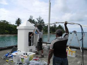
Photo caption: SOPAC Division technical staff carry out routine maintenance on the Sea level station on Manus Island, PNG.
For more information, contact Molly Powers (Tel: +679 338 1377; email: This e-mail address is being protected from spambots. You need JavaScript enabled to view it

