


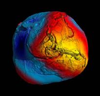
 A fairly important development for Pacific islands mapping initiatives has occurred because of the results of the recently concluded European Space Agency GOCE (Gravity field and steady-state Ocean Circulation Explorer) mission.
The primary result of the GOCE mission is the “most accurate model of the geoid ever produced”. This new and improved data will eventually be incorporated into GPS software of the future and hopefully eliminate the need to devise complicated new national projections to arrive at “real” height readings for any point, when measured with current GPS equipment.
This location has more details http://www.esa.int/esaCP/SEMY0FOZVAG_index_0.html
Photo Caption - Best view yet of global gravity.

