


 Satellite technology has been used in helping to define voting districts put in place for the first time for the recent election held in the Kingdom of Tonga. The election was held on Thursday, November 25.
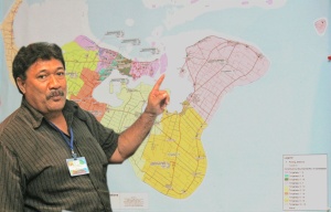
The technology was utilized by the Royal Constituency Commission tasked with the responsibility of organizing voting districts throughout the country.
The Commission created an electoral boundaries map that defined the voting districts, based on the distribution of population.
Mr. Richard Atelea Kautoke, head of the GIS Unit of the Ministry of the Lands, Survey, and Natural Resources, said that the Commission initiated the election district boundaries map as the definitive document that would advise registered of their polling stations.
Mr. Kautoke was in Fiji as a participant in the 2010 Pacific Islands Geographic Information System (GIS) and Remote Sensing (RS) Conference currently being held in Suva, Fiji.
He said that the Commission requested his unit to reinforce the boundaries map by defining its electoral lines using GIS technology.
The GIS was used in Tonga through satellite images to produce a “highly exact technical map” to satisfy Commission requirements to ensure that voting districts were precisely defined.
AusAid, that was responsible for monitoring the election requested further information to be put on the GIS map that would show the exact locations of the polling stations, the amount of voters and candidates in each district.
Also using GIS in elections, but this time in Fiji, SOPAC is assisting the Fiji Election Office also using the technology in developing an asset management system. It is being used to map all polling stations in the field and in listing the equipment available at each of the stations.
Caption: Richard Katoke points towards the GIS Tonga voting distric boundaries map used in the election.

