
Joanne Robbins, a scientist at the Met Office in the UK and working with the Secretariat of the Pacific Community (SPC) has just published a summary of her extensive PhD thesis through SPC.Joanne has been working for the past four years on her thesis which focuses on the temporal and spatial variability of landslides across the whole of Papua New Guinea (PNG) and the links between these events and changing rainfall patterns.
The project was jointly supervised between Professor Michael Petterson (formerly of the University of Leicester, UK and now Director of SPC Geoscience Division), Mr Ken Mylne (Met Office, UK), and Dr Joe Espi of the University of Papua New Guinea. PNG’s Mineral Resources Authority and the Department of Mineral Policy and Geohazards Management were also close collaborators with Joanne and provided support and advise throughout.
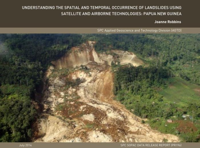
PNG’s position within the highly-dynamic Maritime Continent, and the rugged and varied topography across the PNG Highlands and high parts of islands such as Bougainville and New Britain, mean that numerous meteorological and geological processes interact to result in landslides across the country.
Joanne has documented that landslides occur more regularly at certain times of the year in PNG (e.g. during March April and May) and particularly during the wet La Nina episodes of the El Niño Southern Oscillation (ENSO). Landslides are less likely to occur during September and October and particularly during drier El Nino episodes.
Landslides are also more easily triggered where you have steeply dipping rocks adjacent to a valley, particularly where there are alternations of soft plastic clays and harder limestone or sandstone rock.
To reach these conclusions, Joanne carefully worked through all of PNG’s recorded landslides in recent history and only used data that could be verified in terms of time, place, possible trigger and type of landslide. Ms Robbins mapped all these events on a high-resolution topographic map of PNG and compared the temporal and spatial occurrence of these events against
Tropical Rainfall Measuring Mission (TRMM) satellite-derived rainfall estimates. Based on this analysis Joanne was able to identify that high accumulation, short duration ( 75 days) events are the most likely to result in landslides in PNG.
One remarkable aspect of this research is the fact that it provides information for the whole of PNG which has a highly inaccessible interior. This was possible by extensive use of a range of different types of satellite imagery (TRMM, Landsat, GeoSAR) which provided the raw data which was used to put together various types of maps and models for the whole of the country.
Joanne Robbins states “I am so grateful to all my co-workers and project funders for the opportunity to work on this very exciting project. The research has allowed me to combine my expertise in geographical information systems (GIS) and remote sensing with my natural hazards science background, to develop new science knowledge and skills linked to satellite data interpretation, seismology (science of earthquakes) and physical geology.
The techniques and methods developed throughout this research are more widely applicable (than just PNG) and will support work I am currently doing at the Met Office to develop tools and methods to provide information about natural hazards that are driven by the weather, such as landslides, both in the UK and globally”.
One of the key aspects of the thesis was to assess whether links between landslide occurrence and rainfall existed in PNG and whether the relationships could be modelled, with the view of developing a conceptual early warning/forecasting system for the region.
This required a detailed understanding of the rainfall characteristics which result in landslides and an assessment of contributory causal factors for landslides, such as slope, aspect (slope direction) and rock type.
Professor Petterson states that “Landslides are commonly caused through earthquake activity and heavy rainfall. To understand rainfall-triggered landslides, the seismically-triggered landslides must first be identified and removed from the database. The remaining landslide events are then studied closely in space and time alongside data that tells the story of how much rain (accumulations and intensities) and over how many days the rainfall occurred prior to the actual landslide”.
Joanne also analysed and mapped the topographical and lithological controls associated with PNG landslides. This included assessing the terrain, slope angle, aspect, geology and geological structure, etc. The analysis identified that landslides are also more easily triggered where you have steeply dipping rocks adjacent to a valley, particularly where there are alternations of soft plastic clays and harder limestone or sandstone rock.
Based on this analysis, landslide susceptibility maps were generated, which when combined with temporally-varying rainfall data could offer warnings of potential increases in landslide activity in different parts of the country.
Ms Robbin’s work will inform a range of development related activities and practitioners. Landslides regularly result in wide-ranging, socio-economic impacts including human and livestock fatalities and injuries, and the destruction of villages and towns, roads and other infrastructure.
The resilience and capacity within communities can be increased by (or with) a clearer understanding of the causes of landslides and the development of models which can inform when and where such events are likely to occur. The work will be used for decades to come by government decision makers, engineers, urban developers and rural communities to decrease vulnerability and improve quality of life and the wellbeing of the community.
The link to Joanne’s published article can be found at http://GSD.spc.int/GSD/docs/JRobbins_PNG_Landslides/ and http://ict.GSD.org/library/document/show/1679