
 SOPAC has introduced a navigational positioning service into the region that could make a major contribution in improving the safety of lakes, rivers and the ocean, according to Robert Smith, SOPAC’s Senior Advisor Marine Geophysics, SOPAC is a division of the Secretariat of the Pacific Community (SPC).
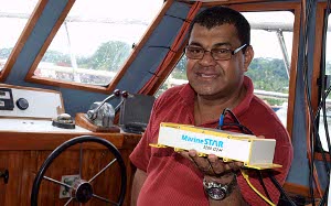
Mr Smith said that the service is called MarineSTAR and utilizes a combination of more than 50 satellites, permanently located base stations and a small transmitter/receiver computer called a Rover, that when operated together, can ensure pinpoint accuracy of a location within 10 centimetres.
In the MarineSTAR network, a base station is a permanently placed reference point that gives a fixed location that the Rover, working with the satellites, can instantly determine.
“Because our survey work is essentially on the water, our position, the speed and direction we are traveling, are computed by the Rover, based on data received from the Marine Star network of satellites and base stations. This provides an exact position in real time (real time means exactly that, what is happening now), to ensure that the mapping is accurate to within 10 centimetres."He said an additional advantage is that the Marine Star system only requires a single Rover unit. “Everything else is provided by the company. It is certainly more cost effective, more efficient and fast.”
Previously Mr. Smith’s team needed assorted equipment to achieve the same accuracy including a portable base station with a limited range of 40 kilometres.
“That meant that every time we went out of range we had to pick up all the equipment and reposition it to a new site to keep in range. It was costly in time, efficiency and expense.”
Mr. Smith said his work addresses a range of activities from surveying the increase of sediment in a river that could result in flooding to charting the seabed of a harbour to ensure that the depth of the water is consistent with the draft of large ocean going vessels.
He said with today’s standards, existing charts in the region were in serious need of updating to modern electronic chart plotters used on vessels of all sizes.
“A ship going through these waters is reliant on current charted data and without frequent updates, it may run the risk of going aground; although well used sea routes are closely monitored to ensure safe shipping lanes and berths.”
“But the acquisition and upgrading of our positional mapping capabilities with the MarineStar Positioning Services will not only revolutionize the future of mapping and charting for SOPAC, but will contribute to a new future resource for improvement in charting the region to internationally recognised standards,” he said.
Mr. Smith said that SOPAC would initially use the system for work offshore Beqa Channel and Rovondrau Bay in Fiji to determine the stability of the seabed and the type of sedimentation that may causing the disturbance. It would then be used in Tonga to collect data for tsunami risk modeling.
CAPTION: Peni Musunamasi, an Electronic Engineer with SOPAC, shows the MarineSTAR Rover, used to help calculate exact locations at sea of up to 10 centimetres.