
 SOPAC member countries have been encouraged to use satellite image data as an essential tool to help in national development, management, security, and protection.
Dr. Wolf Forstreuter, SOPAC’s GIS and Remote Sensing Unit Specialist, said that there were a number of applications that would be of “significant benefit to the countries once they had a better understanding of how to utilize satellite image data.”
Dr. Forstreuter said that most of the data sent from a satellite is used in Geographic Information Systems (GIS) that map targeted areas where a country requests specific information.
He said that these already include food security, land erosion, forestry protection, cyclone and flood damage assessment, landslide detection, town and country planning, climate change indicators, land use, power, water and telecommunication utilities, water catchment protection and agriculture.
In explaining GIS, Dr. Forstreuter said that it really is no different than maps that have been produced in the past, “except these maps are constructed from up-to-date satellite images and are pinpoint accurate in both the images and information.”
He said that satellite technology has become so accurate that it can determine from space individual coconut palms in a specific area, or the size of a school of fish.
SOPAC has been helping island member countries use the satellite technology for over 15 years both in advising on rapid developments in the accuracy and accessibility to satellite usage as well as in ordering images.
“This is a highly technical discipline and we are aware that many of our member countries do not have the expertise to have the overview necessary to select the best type of satellite image for a particular job as well as the most suitable image data offered by the different satellite companies.”
Governments in the early days controlled almost all satellites. But today, commercial companies own many of the satellites.
Dr. Forstreuter said that SOPAC also provides the ability to pre-process the satellite image data into image files that can be displayed on everyone’s desktop computer.
“While it is technical, SOPAC has attempted to make satellite image data as user friendly as possible so that the member countries can easily see the results in a very short time,” Dr. Forstreuter concluded.
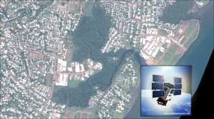
Caption: Suva from 450 kilometres above earth taken with the (insert) QuickBird Satellite. One of the satellites selected by SOPAC to obtain image data for regional countries.