
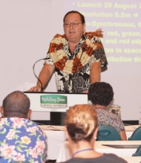
 Close to 200 participants were told by SOPAC’s Director, Dr. Russell Howorth, that the development of Geographic Information Systems (GIS) and Remote Sensing will continue to be a major part of the SOPAC technical support service work programme.
SOPAC provides assistance to 21 island countries in the Pacific region through applied geoscience and technology.
Dr. Howorth was speaking at the 2010 Pacific Islands Geographic Information System (GIS) and Remote Sensing (RS) Conference being currently being held in Suva, Fiji.
In his comments, Dr. Howorth referred to a new regional arrangement in which SOPAC the commission will become SOPAC the division of SPC from the 1st of January 2011.
But he assured those in attendance that “the SOPAC work programme and in particular for the GIS and Remote Sensing Technical Support Services, it will be business as usual and if at all possible, it will get better with improved service delivery to the region.”
Dr. Howorth said that, in fact, the GIS and Remote Sensing has been a critical part of the SOPAC work programme for nearly the past two decades, Ground Information Systems (GIS) is the use of satellite technology to map details in specific areas on earth that can help in planning, security, and evaluation.
Remote sensing is any technology that can be used to create maps without having to physically touch the territory being described. These remote sensing technologies are often deployed from a plane or satellite.
Dr. Howorth provided a brief history of the development of GIS and Remote Sensor, highlighting its growth in the region and brought particular attention to Philipp Mueller, the then Director of SOPAC from l992 to 1998.
He said that Mr. Mueller in l994 prophetically observed that “geographic information systems (GIS) and Remote Sensing have become essential technologies that the SOPAC Secretariat is rapidly adopting. Though these development efforts show little immediate return, they will have tremendous benefits in the future.”
It was the year that SOPAC was given the regional coordination responsibility for GIS and Remote Sensing.
Speaking of the future, Dr. Howorth said that in the merger between SOPAC and SPC that GIs and Remote Sensing applications will grow through this process.
“This is because SPC has more member countries than SOPAC and within SPC, GIS and Remote Sensing applications will grow and will result in stimulating applications in the Pacific island countries. GIS and Remote Sensing applications for vegetation mapping and demography are good examples of this process.”
The conference will end on Friday, November 26